Otranto / Gallipoli, Puglia, Italy. Thursday 25-April-2024
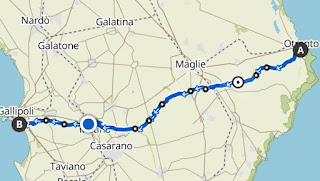
The TranSalentina del Sole is a walk across the Salento peninsula from Otranto on the Adriatic coast to Gallipoli on the Ionian coast. It is 50 km walk passing through 12 communes, done in a single day. The day being, in this case, National Liberation Day, a public holiday in Italy.
We only heard of it because our friend and fellow parkrunner, Nadia, mentioned a couple of weeks earlier that she was going to do it. Having had to cancel a tough walk planned for May, Mary decided we would do this instead. I sent off the application forms and what followed was 10 days of ever longer walks to build up our fitness and stamina.
It was a well organised event partly thanks to our friends helping with the logistics. There were regular water stops, cars to carry baggage, and people if required, and even an ambulance to track the group of about 40 walkers.
We decided to make a mini break of it and drove down to stay with our friends in Castro the night before and go out for a pizza, stay a couple of days and travel to parkrun on Saturday from there.
On the day itself, we had a horribly early start to drive an hour to Otranto for a 7 o’clock assembly and a 7:50 start to the walk.
Also available as [Googlemap], [kmz], [gpx] or [Komoot].
Some introductory words were spoken by Fernando, the main organiser and a man with an impressive walrus moustache. Photo credits are due to him for some of these pictures.
The four parkrunners: me, Mary, Nadia and Julia. Given as this was another of Mary's “bright” ideas my choice of t-shirt was a no-brainer.
Leaving Otranto. The first stretch was very gentle, running alongside an irrigation channel, hence all the reeds.
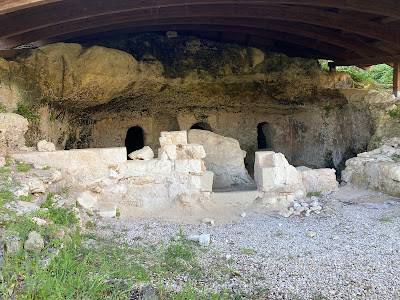
We shortly reached Uggiano la Chiesa and the Byzantine crypt of Saint Angelo.
Giurdignano. We came across a field full of goats. Well, I guess Ricotta di Capra has got come from somewhere.
Water stop 01: 1:08:50 6.19 km.
Team photo at the water stop. The man in the green t-shirt is Riccardo Rella, a pioneer of Trekking in Salento, who started this walk many years ago.
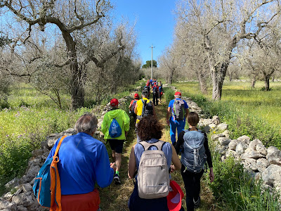
Minervino di Lecce. This was a guided walk with no maps or way-marks so we obviously had to keep together as a group. We didn’t get too strung out and the water stops every 5 to 8 km provided an opportunity for regrouping.
Giuggianello. We passed through a lot of flat countryside with various stone structures dotted about, presumably mostly agricultural stores.
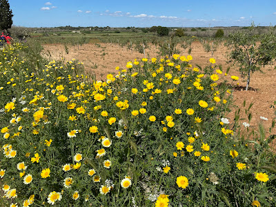
Giuggianello. As it is spring, we were seeing a lot of these yellow flowers that also adorn the Salento parkrun course.
Sanarica. The first of two pillars that we passed that day. Function unknown. As archaeologists are prone to saying, “for ritual purposes “
Water stop 2: 2:55:11 15.5 km.
Muro Leccese water stop. Here you can see our support team in the red hats. Saverio on the left, also Run Director at Salento parkrun, Nadia having a sit down, Mary surveying the scene, and on the right Estienne, sometime parkwalker, parkrunner and volunteer, and today part of the backup crew.
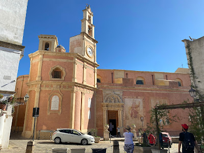
Muro Leccese. La chiesa di Santa Marina - dating back to the 9th-11th centuries with a sixteenth-century bell tower. The interior houses a cycle of frescoes dating back to 1087 which depict the life and works of Saint Nicholas.
Muro Leccese. Given the infrequent train services on southern train routes we were surprised to be held up at the level crossing
We passed several heritage trail plaques in the ground.
Water stop 3: 3:40:56 19.56 km.
Scorrano.
Leaving Scorrano, a sign that we were heading in the right direction
We were accompanied by a lovely dog called Tiffany, named after the film Breakfast at …, who came with us the whole way, running backwards and forwards so probably doing at least half as much again as we did!
Supersano. The last stretch of the pre-lunch section heading for a longer break at the 30km mark.
Supersano. Lots of poppies among the cabbages.
Lunch: 5:35:55 29.56 km.
Supersano. A 45 minute break. We ate the ham and cheese rolls we’d made that morning and were grateful for a chance to sit down, take our boots off, let our feet steam gently and put on fresh socks.
Supersano. Straight after lunch we had the only real uphill but only a short section to the high point of the route at 201 mt above sea level.
Casarano. A scary looking tree but reckon the birds won't be fazed by it.
Our first view of the sea!
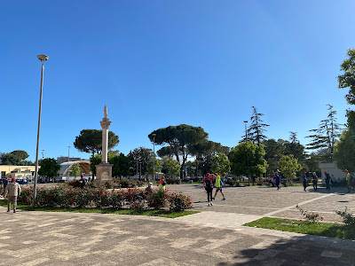
Parabita, Piazza Umberto Primo.
Waterstop 4: 7:16:32 37.90 km.
Parabita, a slightly longer water stop. One of the party, Julia, had done this walk many times before and so knew where to go to get an ice cream!
Alezio. Getting closer to the end as the sun starts to settle towards the horizon.
Water stop 5: 8:18:39 43.37 km.
Outskirts of Gallipoli. The peloton on a narrow path across a field.
After 50 km and nearly 12 hours, we arrived at the Ionian sea just as the sun set. A feature of this event is carrying a portion of water from the Adriatic Sea and with great ceremony, pouring it into the Ionian Sea.
A second parkrun team photo and we are still smiling!
Team photo of the entire crew who made it the full distance, including Tiffany, the dog, and our two paramedics, who services I am glad to say were not called upon.
The End: Walking time 9:35:19. Total time 11:45:57. 50.44 km..
Elevation profile. Nothing too horrendous, mostly easy going.
I joked that it was an Ultra since it is longer than a marathon. Not sure I'd do this particular event again but would happily go out with the same group.









.jpeg)


1 comment:
Grazie di cuore per le belle parole,le quali certamente rendono merito al ragazzo con la maglietta verde, Riccardo Rella, pioniere del Trekking in Salento da oltre trent'anni in cammino. Buon Cammino nella Vita
Post a Comment